
Apple Maps :지도 앱에서 교통 정보를 켭니다
Apple Maps를 탐색 시스템으로 사용하는 경우 교통 정보를 켜야합니다. 설정을 찾을 수있는 곳이 표시됩니다.
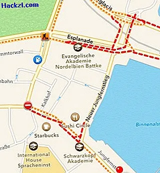
iOS 7 : Apple Maps에서 교통 및 교통 정보 활성화
- "지도"앱을 열고 화면 오른쪽 하단에있는 정보 기호를 누릅니다 (그림 참조).
- 아래의 "교통"옵션을 선택하면 모든 정보가지도에 표시됩니다.
- 빨간색과 노란색으로 표시된 도로는 현재 심하게 혼잡합니다. 작은 기호는 또한 폐쇄, 건설 현장 및 위험 구역을 보여줍니다.
- 참고 : iOS 6에서는 먼저 트래픽 기능을 활성화해야 할 수 있습니다. 이 설정은 "데이터 보호"> "위치 서비스"> "시스템 서비스"의 "설정"앱에서 찾을 수 있습니다.
다음 실용적인 팁에서 Apple Maps를 통해 위치를 보내는 방법을 알려 드리겠습니다.